- Drivetrain(10)
- Audio on the board(38)
- Safe-Skeg(21)
- Clothing and accessories(2)
- Heating and air conditioning(15)
- Anodes(68)
- Boat maintenance(4)
- Galley(21)
- Installation water and sanitary(625)
- Ventilation(27)
- Control system(37)
- Fuel installation(44)
- Exhaust installation(2)
- On-board accessories(11)
- Anchors and accessories(8)
- Navigation(29)
- Binoculars(1)
- Plotters(14)
- Compasses(11)
- Tansducers(1)
- Lighting(80)
- Electrical installation(150)
- Yacht chemistry(1)
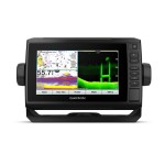
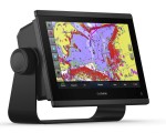
ECHOMAP UHD 62cv Garmin 010-02329-00


Regular price:
product unavailable
 Description
ECHOMAP UHD 62cv Garmin 010-02329-00
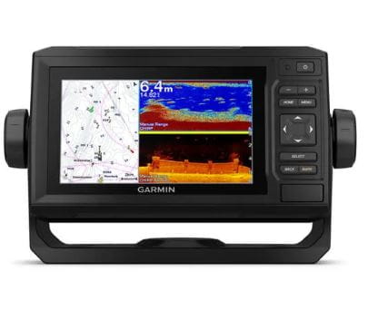
The sunlight-readable 6” chartplotter features a quick-release bail mount, and the transducer bundle adds Ultra High-Definition scanning sonar and CHIRP traditional sonar.
- See below your boat in incredible detail with optional transducer
- Navigate any waters with optional charts and maps
- Manage your marine experience from nearly anywhere
- Create your own maps on the fly and tailor them to fit your needs
OPTIONAL TRANSDUCER BUNDLE
Select the transducer bundle to add a GT24 transducer for Ultra High-Definition ClearVü scanning sonar, which shows you a crystal-clear image below your boat. Plus, you get Garmin high wide CHIRP traditional sonar for remarkable target separation.
OPTIONAL CHARTS AND MAPS
Experience unparalleled coverage and detail with support for optional BlueChart® g3 Vision coastal charts featuring integrated Garmin and Navionics® content.
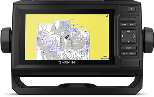
QUICKDRAW CONTOURS
Create personalized fishing maps on-screen with contours. Keep the data to yourself, or share it with the Quickdraw Community on Garmin Connect™.
NMEA 2000® AND NMEA 0183 NETWORKS
Connect to autopilots, digital switching, weather, FUSION-Link™ audio system, media, VHF, AIS and more from one screen.
ACTIVECAPTAIN® APP
Built-in Wi-Fi® connectivity pairs with the free all-in-one mobile app for access to the OneChart™ feature, smart notifications, software updates, Garmin Quickdraw™ Community data and more.
Specification:
- SKU: 010-02329-00
| DIMENSION | 8.6" x 5.1" x 2.6" (21.8 x 13.0 x 6.2 cm) |
|---|---|
| INPUT | Keyed |
| DISPLAY SIZE | 5.4" x 3.1"; 6.2" diagonal (13.7 x 7.7 cm; 15.2 cm diagonal) |
| DISPLAY RESOLUTION | 800 x 480 pixels |
| DISPLAY TYPE | WVGA, NP |
| WEIGHT |
1.6 lbs (0.7 kg) |
| WATERPROOF |
IPX7 |
| MOUNTING OPTIONS | Bail or flush |
Maps & Memory |
|
| ACCEPTS DATA CARDS |
1 microSD card; 32 GB maximum card size |
|---|---|
| WAYPOINTS |
5000 |
| TRACK POINTS | 50,000 |
| TRACKS | 50 saved tracks |
| NAVIGATION ROUTES | 100 |
Sensors |
|
| HAS BUILT-IN RECEIVER | Yes |
|---|---|
| RECEIVER |
5 Hz |
| NMEA 2000 COMPATIBLE | Yes |
| NMEA 0183 COMPATIBLE | Yes |
| GPS | Yes |
| SUPPORTS WAAS | Yes |
Built-in Maps |
|
| (SOUNDER) TIDE TABLES | |
|---|---|
Optional Map Support |
|
| LAKEVÜ G3 | Yes |
|---|---|
| LAKEVÜ G3 ULTRA | Yes |
| (SOUNDER) TOPO | Yes |
| STANDARD MAPPING | Yes |
| GARMIN QUICKDRAW CONTOURS | Yes |
Chartplotter Features |
|
| AIS | Yes |
|---|---|
| DSC | Yes |
| SUPPORTS FUSION-LINK™ COMPATIBLE RADIOS | Yes |
| ACTIVECAPTAIN® COMPATIBLE |
Yes |
| WIRELESS REMOTE COMPATIBLE | Yes |
| SAILING FEATURES | Yes |
Sonar Features & Specifications |
|
| DISPLAYS SONAR | Yes |
|---|---|
| POWER OUTPUT | 500 W |
| TRADITIONAL SONAR (DUAL FREQUENCY/BEAM) | built-in (single channel CHIRP, 70/83/200 kHz, L, M, H CHIRP) |
| CLEARVÜ | built-in 260/455/800/1000/1200 kHz |
Connections |
|
| NMEA 2000 PORTS | 1 |
|---|---|
| CONNECTIONS NMEA0183 INPUT PORTS |
1 |
| 4-PIN TRANSDUCER PORTS | Yes |
Electrical Features |
|
| POWER INPUT | 9 to 18 Vdc |
|---|---|
| TYPICAL CURRENT DRAW AT 12 VDC | 0.7 A |
| MAXIMUM CURRENT DRAW AT 12 VDC | 1.25 A |
| MAXIMUM POWER USAGE AT 10 VDC | 12W |
Files to download:
Shipping costs
The price does not include any possible payment costs
Related products
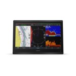
GPSMAP 8412xsv Garmin 010-02092-02
GPSMAP 8416xsv Garmin 010-02093-02
GPSMAP 8422 MFD Garmin 010-01511-00
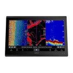
GPSMAP 723xsv Garmin 010-02365-02
ECHOMAP UHD 72cv Garmin 010-02333-00